
Sources for Sammamish Neighbors
Public sources describe a block through parcels, legal interests, civic boundaries, and named organizations. They rarely prove who occupies each home. Start with a subject parcel, then build a bounded set of touching lots. The assessor supplies taxpayer and property fields. Recorded plats, easements, covenants, and transfers explain how those lots relate. City reports identify associations that took part in planning, while election maps show precinct geography without exposing a block roster.
| Source | What It Shows About a Block | Access |
|---|---|---|
| King County Parcel Viewer | Touching parcels, common tracts, roads, address points, taxpayer clues | Free public map |
| eReal Property | Taxpayer, site, mailing, use and legal-description fields per parcel | Free by parcel or account |
| Landmark recorded documents | Plats, easements, covenants, boundary changes and transfers | Free index and unofficial images; copies by request |
| City planning appendices | Named HOAs and civic groups tied to dated planning work | Public documents; verify current status |
| Precinct and annexation maps | Election and city geography around the block | Public maps, not resident rosters |
A taxpayer name is a tax-record fact. It may belong to a person, trust, business, or owner whose mailing address differs from the site. It does not establish the household next door. For a useful neighbor packet, retain the map date, parcel identifiers, side or rear relationship, common-tract notes, and official source. Omit private details that do not help explain the block.
Touching Sammamish Parcels
King County Parcel Viewer is the main tool for defining an immediate Sammamish block. Search an address, parcel number, condo name, or intersection. Record the subject parcel, jurisdiction, site address, legal description, and map date. Then click each lot that shares an edge. Label it front, rear, side, access strip, road, water edge, or common tract. A lot inside a circular radius is not necessarily adjacent.
The viewer offers Select parcels, Add to selection, Buffer Selected parcels, Measure, and Export tools. Its parcel, zoning, political-boundary, address-point, and aerial layers help explain the shape of a block. County lot lines are approximate, so they are not legal survey proof. Recorded plats or a survey are the next source when an edge matters.
The manifest capture of Parcel Viewer preserves the interface used for an adjacent-lot search.
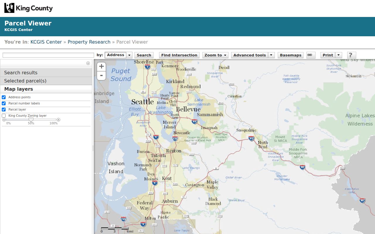
The map supplies a repeatable parcel set while its warning keeps approximate lines from being treated as a survey.
Reading Sammamish Parcel Roles
Open each selected parcel in King County eReal Property with the property-tax account or ten-digit parcel number. The report may show taxpayer name, mailing address, site address, legal description, jurisdiction, present use, value, lot area, levy code, units, and buildings. Compare the mailing and site fields rather than assuming they match.
A city project appendix demonstrates why that distinction matters. It keeps taxpayer mailing city and ZIP in fields separate from site address, site ZIP or ZIP+4, and site city. This is an address-reading lesson, not a current ownership roll. A mailing city outside Sammamish can coexist with a Sammamish site, and a postal label alone does not settle the municipal boundary.
- Parcel
- A mapped unit of land identified by the county for tax and record purposes.
- Situs address
- The physical site address, which may differ from the taxpayer's mailing address.
- Common tract
- Land shared for access, drainage, open space, or another plat purpose.
- Easement
- A recorded right to use part of another parcel for a stated purpose.
Note: A taxpayer is a record role, not proof that the named person lives on the parcel.
Sammamish Neighborhood Organization Clues
The City of Sammamish HOA registration route is an organization and notification lead. Its form fields and public output were not visible in unattended inspection, so no public roster should be assumed. A city planning toolkit names groups and areas such as Highland Park, Eagle Shores, Brookshire, Aldarra Estates, Arbors at Pine Lake, Klahanie, Providence Point, Beaver Lake, Trossachs, Hunters Ridge, and Hunters Place.
| City Source | Examples or Scope | What It Establishes |
|---|---|---|
| HOA registration route | City notification contact | Organization lead, not membership |
| City planning toolkit appendix | Highland Park, Brookshire, Klahanie, Beaver Lake and more | Dated planning inventory |
| Community visioning report | Providence Point, Klahanie and edge groups | Civic geography and relationships |
| Road project records | 2016 to 2019 stakeholder meetings | Dated group participation |
Planning documents are historical snapshots. Verify an association's present name, boundary, and contact before relying on it. A group listed as a project stakeholder shows civic participation on that date, not that every member lived beside the project.
Sammamish Neighbor Boundaries Change
Klahanie's annexation took effect January 1, 2016. That date is a useful marker when comparing county and city files. Mystic Lake updates, subdivisions, road dedications, and parcel changes can also alter how a block appears over time. Use the county city-annexation layer and city or election boundary layer with their edition dates.
For historical neighbor research, preserve the label used by the record. Older sources may place the same area under King County, Issaquah, Redmond, Beaver Lake, Inglewood, or another plateau name. Do not apply today's Sammamish label to an older record without explaining the date and jurisdiction.
Map a Sammamish Neighbor Block
Begin at one exact address and walk outward only as far as the question requires. The bounded approach is easier to repeat and less likely to sweep unrelated parcels into the result. Keep a simple log with the source, date, parcel, geographic relation, and what each field proves.
- Locate the address in Parcel Viewer and confirm the city jurisdiction.
- Select each touching parcel and describe its physical relation to the subject.
- Use eReal Property to compare taxpayer, mailing, site, use, and legal-description fields.
- Inspect plats and easements when a road, common tract, or shared edge affects the block.
When the question expands from the immediate block to a whole named road, use the Sammamish street directory workflow. That process follows address-keyed records along the entire street rather than expanding a small neighbor packet.
Sammamish Precincts Are Not Rosters
King County's Sammamish precinct map supplies precinct identifiers, district labels, parks, roads, and the city's relationship to nearby jurisdictions. Keep the map year because election geography changes. Aggregate turnout can describe civic activity, but it cannot identify each person on a block.
My Voter Information requires any three of first name, last name, birth date, and house number. It is not a tool for sweeping an unknown block. Public voter lists are handled separately under RCW 29A.08.720, with restrictions on solicitation and advertising use. Address Confidentiality Program participants may use a substitute address that must never be treated as a physical home.
Sammamish Neighbor Source Choices
Official records and commercial neighbor tools differ in both provenance and control. An official source identifies its custodian, field meaning, date, and access rule. A commercial result may merge stale public and nonpublic clues without showing why two names were joined. Use the official source that fits the exact question.
| Choice | Strength | Limit |
|---|---|---|
| County parcel and tax systems | Named custodian, parcel and dated tax fields | Taxpayer does not prove occupancy |
| Recorder and city files | Filed instruments and dated civic context | Index may require an image or archive request |
| Commercial neighbor category | May offer a quick lead | Source, date and identity matching may be unclear |
A complete search may properly end with a private roster, protected address, unavailable image, or source gap. Record that limit and use the lawful custodian route. Do not fill the gap with an unverified name.
Privacy for Sammamish Neighbors
No official source reviewed offers a current public household roster for each Sammamish block. Assessor records identify taxpayers, not all occupants. Planning appendices identify organizations, not their full membership. Precinct maps show geographic units, not names. Court searches redact addresses, phone numbers, and birth dates, while vital records and protected-address programs impose their own gates.
Submit a narrow request for an existing city record only when the record itself serves a lawful need. Accept redactions. Do not ask an agency to create a list, and never combine public sources to track a person. If the next step requires entry to a private directory or reconstruction of a protected address, stop.
Lawful use. Research about a Sammamish block must remain personal and lawful. Public records do not permit surveillance, unwanted contact, threats, or harassment.